The day had arrived. All the planning and preparations were done, and it was time to head down to the start of the
AZT 300. I somehow convinced Jake to ride with me and we got dropped off at the trailhead on Tuesday night in preparation for our ride. Thanks Dad!
 |
| No turning back! |
 |
| I look kind of happy here. |
We looked around for a bit, then settled in and tried to get some sleep.
Day 1: Parker Canyon Lake to Kentucky Camp
The alarm went off before 5 am and we packed up and headed out. The
East Canelo Hills can be tough on bike and rider, so we took a slower pace and rode gingerly to avoid putting holes in our tires.
 |
| Still sort of happy. |
 |
| A nice stretch of trail. |
 |
| Some pushing is required. |
We made it out of the East Canelos around 10 am and continued into the
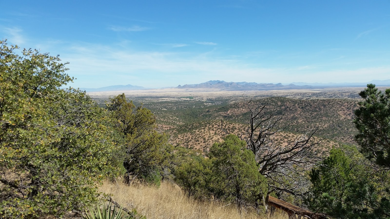
West Canelos, which were supposed to be easier. It soon got hot and became clear it they wouldn't be any easier. We saw plenty of wildlife, including deer, javelina and the elusive coatimundi!
 |
| Views. |
 |
| Views. |
 |
| Nice trail. |
 |
| Wide open. |
 |
| Many gates. |
 |
| We skipped this water source. |
 |
| Almost done with the Canelos. |
We got off the trail around 2 pm and were grateful to see some downhill pavement leading into Patagonia. We met a thru-hiker who was out of water so we gave him a bottle which he quickly drank. He said he'd be fine making it into town so we left him
in search of pizza.
 |
| Resupply. |
While waiting for pizza I drank about a liter of ice cold orange soda, which sounded like a good idea at the time. We ran into
Scott and
Eszter, who gave us the heads up about a potential fire detour near Molino Basin. We ate our pizza and took some leftovers to go on the road up to Sonoita.
 |
| Hot pizza can fix many things. |
On the road I started feeling gas pains from chugging all that soda. Lesson learned! I had to take my time on this relatively easy stretch to Sonoita. As a side note, I'm pretty sure 20% of the cars on the road were Border Patrol.
 |
| On the road. |
After getting a few more snacks (apple pie!) at the store, we turned north and started on the dirt roads that lead to the Arizona trail.
 |
| Sonoita Mini Mart. Family owned for over 40 years. |
We stopped and ate the leftover pizza just before dark.
 |
| Cold pizza can fix things too. |
I was feeling a bit better at this point, but started having saddle sores. I tried to ride standing up as much as possible.
 |
| Stand and deliver. |
 |
| No smuggling or illegal immigration was encountered in this area. |
There was some nice sections of trail in Gardner Canyon and we made it into Kentucky camp just before 10 pm. The caretaker came out and let us sleep on the porch and pointed us to the water and bathroom behind the main building. I fell asleep 22 seconds after laying out my sleeping bag.
 |
| On the porch at Kentucky Camp. |
Day 2: Kentucky Camp to Tucson
We got up at 5 am and got back on the trail.
 |
| Making friends. |
 |
| Are we there yet? |
After some dirt roads we reached some sweet singletrack - the Kentucky Camp section!
 |
| That view. |
 |
| Money shot. |
 |
| Mount Wrightson et al. |
My saddle sores were now very painful so I could only stand and pedal, or walk. I was trying to stay on top of eating and drinking and seemed to be doing OK until we hit
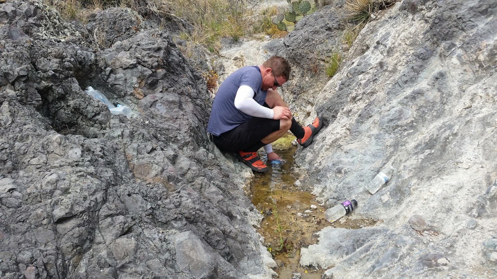
Las Colinas. It got really hot and I had to slow down to avoid overheating. We were starting to get a bit concerned about running out of water until we came across a seep where we filtered some water. It tasted like dirty socks, but it's better than getting dehydrated! We did lose some time when I backtracked to look for my missing phone, only to realize Jake was still carrying it after taking a picture.
 |
| Jake ascends in Las Colinas. |
 |
| Filtering questionable water. |
The
Las Cienegas section was fun, fast and flowy. We crossed under AZ-83 and I-10 and passed by Cienega Creek. The way down to the creek for water didn't seem very fun, so we pressed on with hopes of reaching
Colossal Cave before it closed.
 |
| This part was fun. |
 |
| Tucson in the distance. |
 |
| Jake riding a fast downhill section. |
 |
| Red dirt. |
 |
| Going under AZ-83. |
 |
| Going under I-10. |
 |
| My bike leaning against a sign. |
After a bit of climbing we realized we wouldn't make it to Colossal Cave and opted to turn down to
La Posta Quemada Ranch. They had cool water and bathrooms, but no food. I knew had been closed for several years, but was secretly hoping it was open. I would have paid good money for a burrito right then!
 |
| La Posta Quemada Ranch. |
 |
| Fresh water and shade. |
I could now sit and pedal, and I was reminded of the Black Canyon Trail as we made progress up the trail past
La Selvilla. Pistol Hill was nice and fast in the dark and Hope Camp was uneventful as well. I felt pretty good through here.
 |
| Golden hour. |
We hit the road and were hoping to make it to Saguaro Corners for a bite to eat. Alas, we arrived half an hour too late and pressed on to McDonald's where I had the best chicken sandwich ever.
 |
| Something's got to be open! |
We had already decided it was too late to head up Redington Road, so we were planning on riding some extra miles down to a hotel. After loading back up to go, I started shivering, even though it was plenty warm out. I figured my ride was over, but I would wait until morning to be sure. I threw on layers and starting riding and warmed up a bit by the time we arrived. We checked in, showered, and went right to sleep.
Day 3: Tucson to Mt. Lemmon
I didn't set an alarm and woke after 6. I still wasn't feeling great, but decided to get some food and see how I felt. We ate the continental breakfast and then I replaced my bent derailleur hanger. I decided I could at least ride to the store to get some supplies. We also got breakfast burritos and I felt like I could continue.
 |
| Bike surgery. |
 |
| We don't look too bad after a shower and a night's sleep on a bed! |
We checked emails and found that the Molino fire was out and the roud and trails were open - no detours needed. This is good since I didn't really have a way to load up a detour track on my GPS. We headed out of Tucson around 10 am (so late!), carrying lots of food and water.
 |
| Get out of town. |
 |
| Redington road. |
 |
| Redington road. |
It got hot, so we took our time getting up the road and onto the rough jeep trails of Chiva Falls. We finally made it back to the
Arizona Trail.
 |
| Jeep road and military helicopters. |
 |
| Jeep road. |
 |
| Italian Trap Tank. |
 |
| Rideable gate. |
 |
| Bikes get tired too. |
 |
| This is why we ride. |
 |
| Climb up to Redington Road. Weren't we just on Redington Road? |
 |
| Some mountains. |
 |
| More mountains. |
 |
| Money shot part two. |
 |
| Rugged country. |
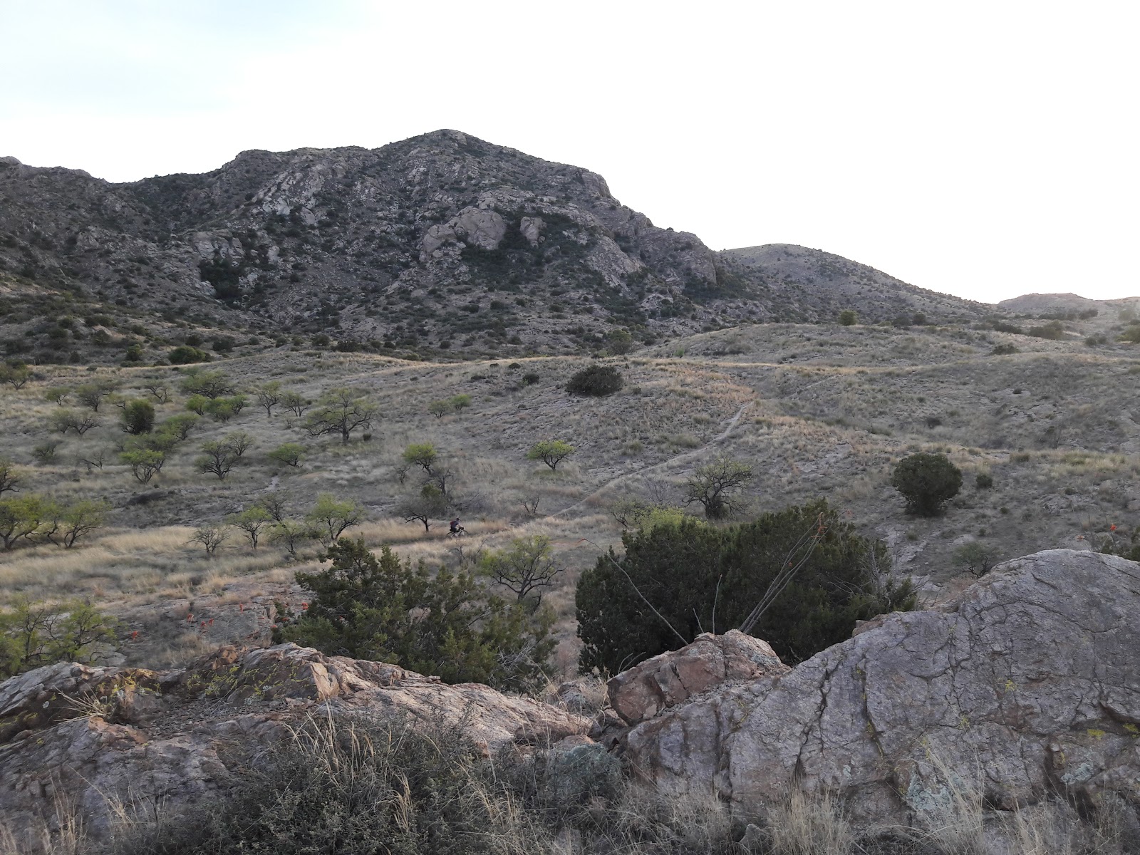
There were a couple of nice sections interspersed with some tough trail. The trail eventually becomes too steep and rough to ride. We had reached the dreaded Molino hike-a-bike. For some reason, I didn't take many pictures here.
 |
| Wild horse is not impressed. |
We wanted to reach the campground and the highway before stopping, but finally stopped to eat at the top of the hike before continuing down to the campground.
 |
| Chips and salsa and avocado. |
After a brief stop at the campground, we pushed on through the Prison Camp section, walking a lot of the uphill sections. We came across another intermittent stream and filtered some water since we didn't know if there was any water until Summerhaven.
 |
| Hike-a-bike. |
We set up camp just before the
Gordon Hirabayashi campground. My air pad would not inflate, but I was too tired to care and laid down anyway. It was cold night.
Day 4: Mt. Lemmon to Oracle
We got up around 6 and started up the highway toward the top of Mt. Lemmon and the town of Summerhaven.
 |
| I don't want to get up. |
We were passed by several of the faster riders who had started a day or two after us - impressive! AS we headed up the paved road, my saddle sores and legs conspired against me and I alternated between riding slowly and walking.
 |
| Climbing. |
 |
| Climbing. |
 |
| Climbing in front of climbing. |
 |
| Taking a break from climbing. |
 |
| Watch out for BEAR TAG. |
 |
| Last break before the top. |
Near the top, there's some downhill pavement where my GPS said I hit 47 MPH (yikes!), but that quickly ended and the road when back up, peaking at 8100 feet above sea level. I finally turned downhill again and rolled into Summerhaven and ate
the best cheeseburger and fries ever!
 |
| Nothing else matters. |
 |
| No autographs please. |
We had originally planned on doing the entire ride in about 4 days, which meant our hall pass was almost up. We made the decision to finish in Oracle and made the arrangements for pickup and started onto
Oracle Ridge.
That is some brutal trail. I'm not sure why it even exists. Fortunately the views are amazing, seemingly going on forever.
 |
| Begin traverse-o-death. |
 |
| Downed trees. |
 |
| More views. |
 |
| Rugged trail. |
 |
| Exposure. |
 |
| Quite windy. |
There were a few rideable sections, but mostly we pushed and carried our bikes down, up and down again. We finally got to the Cody Bottom section which was mostly rideable,
 |
| Downhill and rideable! Don't burn up your brakes! |
 |
| Jake explores alternate lines. |
 |
| Let's finish this. |
 |
| One last climb to keep us honest. |
 |
| The sun sets on our adventure. |
My family was
spot-stalking us and found a dirt road that intersected the trail and were waiting for us well before Oracle. We were glad to not have to ride ten more miles to the highway.
 |
| We made it 200 miles. |
We may not have finished all 300 miles, but it was great to see my wife and kids and dog. It was also good to see my sister-in-law and her husband who came out to meet us. Thanks for the support guys! Thanks Jake for attempting this craziness with me!
 |
| Happy... to be done! |
While it went slower than planned and we didn't make it as far as we thought, we had an adventure and learned a lot. As I was pushing my bike on Oracle Ridge I contemplated my ride and thought "This is stupid, this trail is terrible, why am I doing this? I'll never do this again... but next time I know what I'll do better!".
Here is the ride log:


